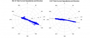
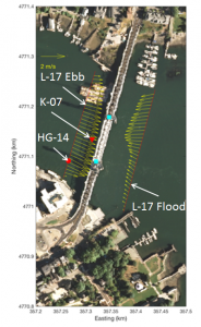
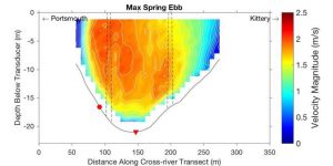
A tidal energy resource assessment was performed for a potential long term tidal energy conversion installation on the Memorial Bridge in Portsmouth New Hampshire in the Piscataqua River. The purpose of the assessment was to select and size a turbine for the location, determine the feasibility of and size a battery bank and to quantify the amount of available kinetic energy in the water that could be converted into electrical energy. The assessment primarily used data collected by one bottom deployed acoustic Doppler current profiler (ADCP) survey (HG-14) performed near the planned deployment site to characterize the currents at the site. The data from an additional bottom mounted ADCP survey (K-07) and vessel mounted ADCP transects were used to provide additional information about the currents nearby the site.
Based on the tidal current data collected during the ADCP survey closest to the deployment and average estimated power requirements current data, a turbine and rotor size were selected. A systems model was used to simulate a battery bank, tidal generator, and a power load. Using this model, utilization factors for various battery-rotor-load configurations were compared to the available tidal energy during the survey period. An annual energy production estimate (AEP) was made based off a commercially available tidal turbine’s power curve and the ADCP survey results.
A crossflow vertical axis turbine with a 3mx2m rotor was selected for this site. It was estimated that this turbine would produce approximately 2kW of power on average, and 10kW at peak. The turbine is estimated to produce 13,008kWh per year of electrical energy which is enough energy for approximately 2 US homes.
This work is in preparation for a journal paper by authors Ian Gagnon, Martin Wosnik, Thomas Lippmann, Ken Baldwin, and Erin Bell to be published in the International Journal of Marine Energy.